Default Dimension Properties
La catégorie Propriétés de dimension par défaut contient des paramètres qui seront les paramètres par défaut pour toutes les nouvelles dimensions. créé. Ces paramètres peuvent être remplacés pour chaque dimension.
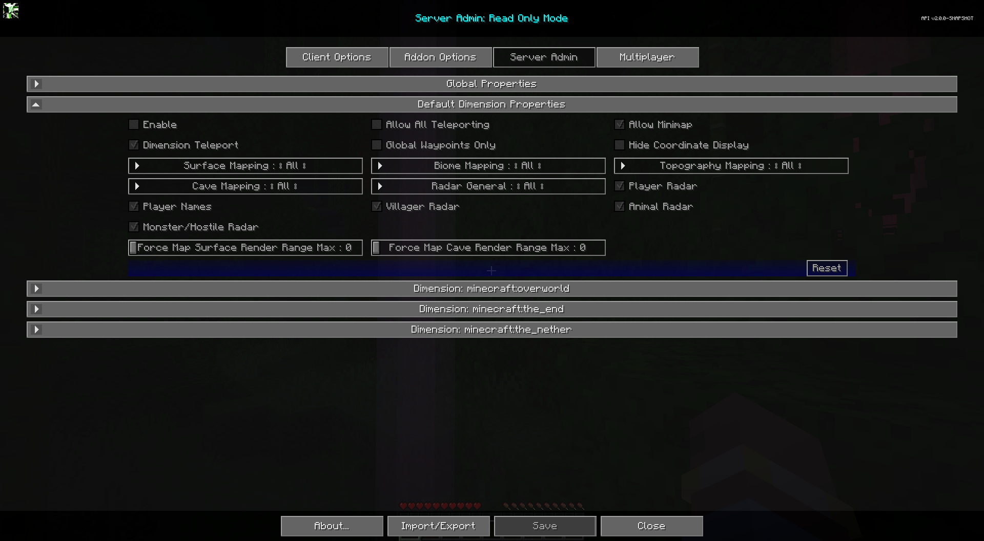
Toggles
| Basculer | Descriptif |
|---|---|
| Activer | L'activation de cette dimension remplacera les propriétés globales de cette dimension. |
| Autoriser la mini-carte | Activez ou désactivez la mini-carte. |
| Masquer l'affichage des coordonnées | Masque tous les affichages de coordonnées, empêche la modification des valeurs de coordonnées pour les waypoints. Remplace la plupart des affichages de coordonnées par le texte « Emplacement inconnu ». N'affecte pas les noms de waypoints existants. |
| Waypoints mondiaux uniquement | Lorsqu'il est activé, les joueurs peuvent uniquement afficher et activer la visibilité des waypoints globaux. La création, la modification et la suppression de waypoints personnels sont désactivées. |
| Autoriser toutes les téléportations | Permet la téléportation des waypoints et du menu contextuel plein écran. La téléportation par waypoint uniquement est prioritaire. |
| Téléportation dimensionnelle | Activez la téléportation Cross Dimension Waypoint pour les utilisateurs non opérationnels. Les utilisateurs OP peuvent toujours l'utiliser. |
| Radar des joueurs | Si les joueurs peuvent voir d'autres joueurs sur la carte. |
| Noms des joueurs | Si les joueurs peuvent voir les noms des autres joueurs sur la carte. |
| Radar villageois | Si les joueurs peuvent voir les villageois sur la carte. |
| Radars pour animaux | Si les joueurs peuvent voir des animaux sur la carte. |
Autres paramètres
L'option par défaut pour chaque paramètre ci-dessous est marquée d'un texte gras.
| Paramètre | Options | Descriptif |
|---|---|---|
| Forcer la plage de rendu de surface de la carte Max |
|
Forcer tous les joueurs à respecter une distance maximale de rendu de surface pour la carte. 0 pour utiliser les paramètres client. Ce paramètre force uniquement le maximum, il n'augmente pas leur plage de rendu. Cette valeur n'est pas reflétée dans les options de Cartographie du client. |
| Force Map Cave Render Range Max |
|
Forcez tous les joueurs à respecter une distance maximale de rendu de la grotte pour la carte. 0 pour utiliser les paramètres client. Ce paramètre force uniquement le maximum, il n'augmente pas leur plage de rendu. Cette valeur n'est pas reflétée dans les options de Cartographie du client. |
| Cartographie des surfaces |
|
Cartographie de surface pour tous, opérations, aucun. |
| Cartographie topographique |
|
Cartographie topographique pour tous, opérations, aucun. |
| Cartographie du biome |
|
Cartographie du biome pour tous, opérations, aucun. |
| Cartographie des grottes |
|
Cartographie des grottes pour tous, opérations, aucun. |