Dimension : minecraft:overworld
La catégorie Dimension : minecraft:overworld contient des paramètres qui seront les paramètres par défaut pour l'overworld. dimension.
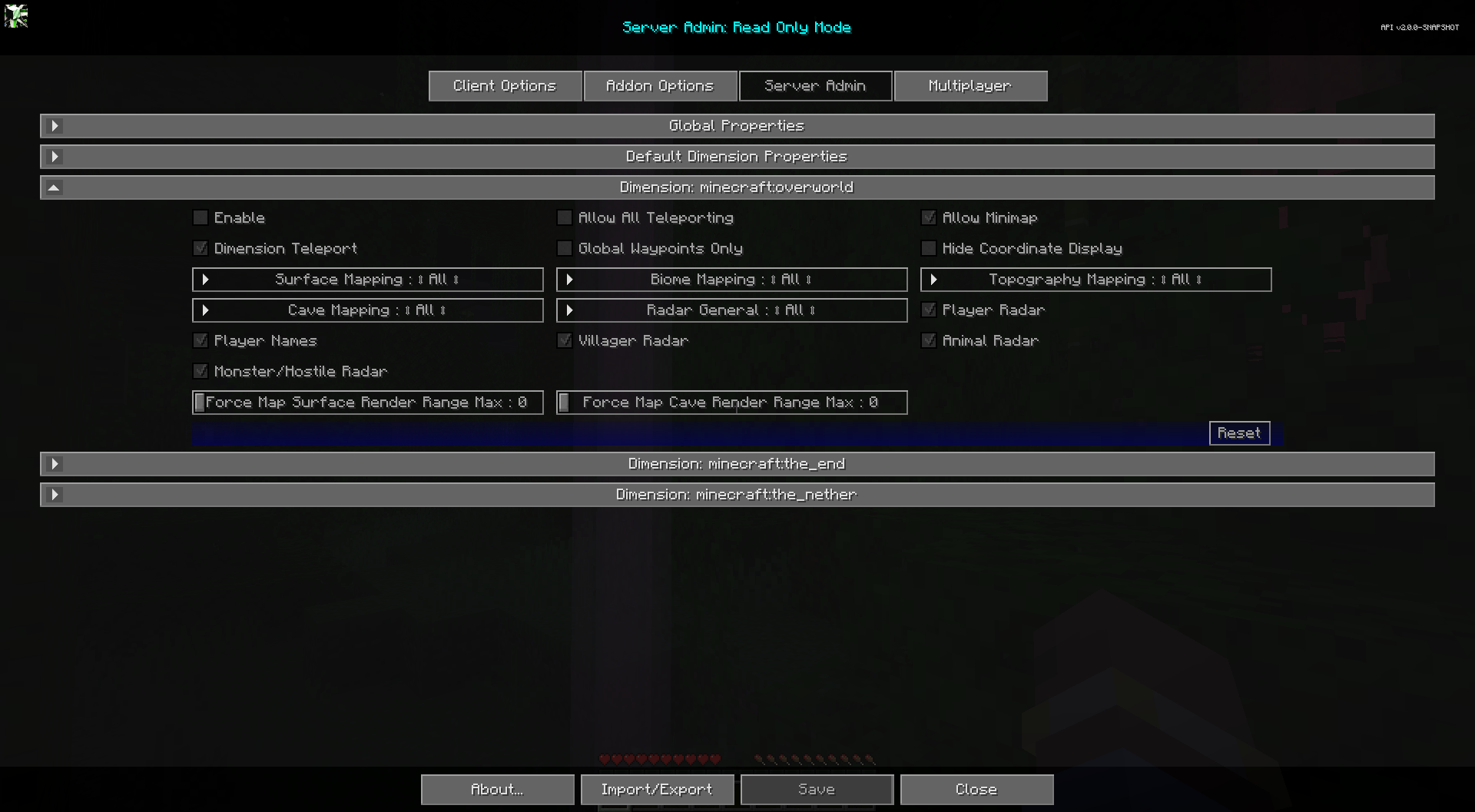
Toggles
| Basculer | Descriptif |
|---|---|
| Activer | L'activation de cette dimension remplacera les propriétés globales de cette dimension. |
| Autoriser la mini-carte | Activez ou désactivez la mini-carte. |
| Masquer l'affichage des coordonnées | Masque tous les affichages de coordonnées, empêche la modification des valeurs de coordonnées pour les waypoints. Remplace la plupart des affichages de coordonnées par le texte « Emplacement inconnu ». N'affecte pas les noms de waypoints existants. |
| Waypoints mondiaux uniquement | Lorsqu'il est activé, les joueurs peuvent uniquement afficher et activer la visibilité des waypoints globaux. La création, la modification et la suppression de waypoints personnels sont désactivées. |
| Autoriser toutes les téléportations | Permet la téléportation des waypoints et du menu contextuel plein écran. La téléportation par waypoint uniquement est prioritaire. |
| Téléportation dimensionnelle | Activez la téléportation Cross Dimension Waypoint pour les utilisateurs non opérationnels. Les utilisateurs OP peuvent toujours l'utiliser. |
| Radar des joueurs | Si les joueurs peuvent voir d'autres joueurs sur la carte. |
| Noms des joueurs | Si les joueurs peuvent voir les noms des autres joueurs sur la carte. |
| Radar villageois | Si les joueurs peuvent voir les villageois sur la carte. |
| Radars pour animaux | Si les joueurs peuvent voir des animaux sur la carte. |
Autres paramètres
L'option par défaut pour chaque paramètre ci-dessous est marquée d'un texte gras.
| Paramètre | Options | Descriptif |
|---|---|---|
| Forcer la plage de rendu de surface de la carte Max |
|
Forcer tous les joueurs à respecter une distance maximale de rendu de surface pour la carte. 0 pour utiliser les paramètres client. Ce paramètre force uniquement le maximum, il n'augmente pas leur plage de rendu. Cette valeur n'est pas reflétée dans les options de Cartographie du client. |
| Force Map Cave Render Range Max |
|
Forcez tous les joueurs à respecter une distance maximale de rendu de la grotte pour la carte. 0 pour utiliser les paramètres client. Ce paramètre force uniquement le maximum, il n'augmente pas leur plage de rendu. Cette valeur n'est pas reflétée dans les options de Cartographie du client. |
| Cartographie des surfaces |
|
Cartographie de surface pour tous, opérations, aucun. |
| Cartographie topographique |
|
Cartographie topographique pour tous, opérations, aucun. |
| Cartographie du biome |
|
Cartographie du biome pour tous, opérations, aucun. |
| Cartographie des grottes |
|
Cartographie des grottes pour tous, opérations, aucun. |